Ralene Nelson, Walnut Grove REALTOR, assists buyers and sellers with homes for sale in Walnut Grove.
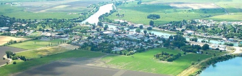
Walnut Grove is a census-designated place (CDP) in Sacramento County, California, United States. It is part of the Sacramento–Arden-Arcade–Roseville Metropolitan Statistical Area. The population was 1,542 at the 2010 census, up from 669 at the 2000 census.
Established in 1850 by John W. Sharp, Walnut Grove is one of the earliest settlements along the Sacramento River. Sharp journeyed west from Ohio with his young family and chose the site of Walnut Grove because of the abundant walnut and oak forests in the area. The town quickly prospered as an agricultural center and riverboat stop (the forests were timbered for steamboat firewood). It was also a major shipping port by 1865 for agricultural produce and fish, with the Bartlett pear as its primary product. By 1870, it had become a thriving town full of small businesses (many owned by the Sharp family), a school, post office, and Union Guard Armory.[citation needed]
After Sharp’s death in 1880, the heirs sold a large portion of the estate to Agnes Brown and her son Alex. The Brown family subsequently became heavily involved in the commercial life of the community, operating a general store, hotel, and asparagus packing house[citation needed] , as well as the Bank of Alex Brown.[5] Due to the demands for rich agricultural land over time, although the town has remained compact in size, it holds the distinction of being the only river town along the Sacramento River to occupy both the east and west riverbanks.[citation needed]
Ferry service operated for many years between parts of town on either side of the river until the first bridge was opened in 1916. The bridge, since replaced by a modern span, was the first cantilevered counterweight bascule drawbridge constructed west of the Mississippi River. It was officially opened by the Governor of California,[which?] who traveled with various dignitaries to Walnut Grove on the gubernatorial yacht.[when?][citation needed]
As early as 1914, a large Japanese community lived in Walnut Grove. The Nichi-Bei Nenkan (Japanese American Yearbook) of 1914 includes a directory of 67 Japanese-owned businesses, including one tofu shop: Sakai Tofu-ya. There was still a tofu shop in town in 1975, according to The Book of Tofu.[citation needed]
The community was racially segregated up to the start of World War II. Only whites were allowed to own homes on the west side of the river. Even on the east side, the Asians separated into a Japanese section and a Chinese section. There were two elementary schools [a “white” school and Walnut Grove Oriental Elementary] until the Japanese were forcibly moved out of the area at the start of World War II. Then, the two elementary schools [up to Grade 8] were combined. After elementary school, the students were bused to Courtland for high school, until that school became identified as an earthquake hazard.[citation needed]
The Chinese residents immigrated from two different areas in the Delta region in Guangdong [Canton], China; immigrants from Chung Shan resided in Locke, while those from Toi Shan county populated Walnut Grove. During the Sino-Japanese War in the 1930s, the Walnut Grove-Locke-Isleton area was a prime target for visiting Chinese government VIPs to raise funds for the Chinese government.[citation needed]
The principal activities in the Walnut Grove Chinese community were operating illegal gambling houses and Chinese restaurants. These services were primarily for migrant farm workers from the Philippines. “Whites” were not allowed to enter for fear they might be police authorities. Routine police raids were staged during election times to demonstrate the Sacramento County Sheriff’s “fight against crime”.[citation needed]
In the early 1930s, Walnut Grove was a thriving community until fire again consumed the Chinese section in the mid-1930s. In its glory days of the 1930s and early 1940s, a daily shuttle operated by the Ow family carried Chinese to and from San
Francisco; it also accepted and executed orders for merchandise from San Francisco. The route started from Courtland with stops at Locke, Walnut Grove, and Isleton and returned nightly.[citation needed]
After World War II, gambling operations ceased. Members from the small Chinese community in Walnut Grove moved to the cities and many elder Filipinos returned to their homeland.[citation needed]
Sugar beet harvesting was active up to the late 1940s. There were two leading areas where beets were unloaded from trucks into a hopper, then conveyed up a belt to fill Southern Pacific railroad cars for the trip north to Sacramento for processing. Asian women worked in fruit packing houses throughout the Delta area [Locke, Walnut Grove, Ryde, Isleton] while men worked in the fields.[citation needed]
In 1961, documentary photographer Pirkle Jones did a photo essay on Walnut Grove.[citation needed]
Sites of interest
Towers
Walnut Grove’s location has made it the site of a rare collection of very tall radio and television transmission towers. The first major tower here was the KXTV/KOVR/KCRA Tower built in 1962, which dominated the skyline for over twenty years with its 1,548 foot height. In 1985 the old tower was joined by taller structures. The guyed KXTV/KOVR Tower is, with a height of 2,048 feet, one of the tallest constructions in the world. Two other guyed towers of similar height are the 1,996 foot high Channel 40 Tower, KTXL, and the 2,000 foot high Hearst-Argyle Tower. Towers sited here at the natural corner of the California Central Valley have line of sight coverage of flat valley floor for over 60 miles(100 kilometers) to the north and to the south-southeast, and quite good coverage into the Sierra foothills and mountains across the valley to the northeast and east. However, these towers and their guy-wires are a significant hazard to aircraft, which can otherwise freely cross most of the Central Valley at 656 feet of altitude.[citation needed]
Delta Meadows State Recreation Area
Located along the Railroad Slough Levee, and accessed from the River Road between Walnut Grove and Locke, via a small gravel road just north-east of the Delta Cross Channel, an water diversion facility on the Sacramento River. Additionally, a docent program through Delta Natural History Association provides canoes with guides in the spring and fall, reserved through Brannan Island State Park.
Source: Wikipedia.org